Who doesn’t love a waterfall?
And it’s not just dramatic beauty that attracts us to waterfalls; they actually make us feel better.
That’s not just an opinion. There’s science behind people’s attraction to falling water and water in general.
Did you know that waterfalls release negative ions, and once those ions get into our bloodstream, serotonin is stimulated, and we feel happier?
It’s true; we are attracted to waterfalls because they make us happy!
And… the visual appeal of a waterfall also stimulates our brains because humans constantly try to find visual patterns. We are mesmerized to watch for patterns, just as we are mesmerized by the flickering flames of a campfire.
And then there is the smell and sound of waterfalls.
How often have you heard a waterfall first, and your sense of excitement is piqued just by the sound?
And once near the falls, the smell of the fresh spray and mist is like an elixir for the soul.
We can wax on poetically about why we love waterfalls, but you get the point!
And now, we’ll get to the point.
Below are our choices for the Top Five Alberta Waterfalls, in no particular order.
What do you think?
Have we missed your favourite waterfall? Let us know on Instagram and Facebook.
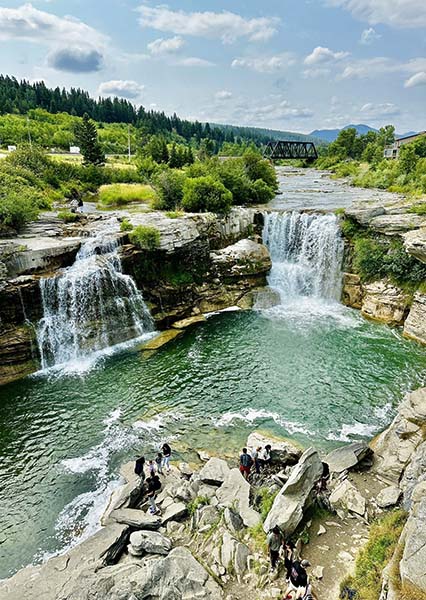
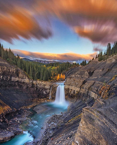
Lundbreck Falls
Easy road access to a picturesque, split-flow waterfall that wraps around an island and plunges 12-metres into a canyon on the Crowsnest River. What’s not to love?
This roadside attraction in southern Albertas is good to visit any time of year, with dramatic backdrops, including a train bridge, forested foothills and distant mountains.
In winter, the plunging water creates giant hanging icicles along the canyon walls, perfectly framing the twin waterfalls.
Lundbreck Falls is situated near the hamlet of Lundbreck in southern Alberta, approximately 26 km northwest of Pincher Creek. Access the falls via Highway 3.
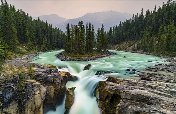
Sunwapta Falls
Nestled along the scenic Icefields Parkway in Jasper National Park, Sunwapta Falls is a breathtaking natural spectacle comprised of upper and lower cascades fed by the Athabasca Glacier.
The Indigenous Stoney language aptly names the falls ‘Sunwapta,’ meaning “turbulent water,” a sight most vibrant during the late spring when glacial melt surges at its peak.
The easily accessible upper falls boast an impressive 18-meter drop, creating a torrent of plunging water around a thumb of rock in the middle of the falls.
A serene 1.3 km hike through a lodgepole pine forest reveals the lesser-visited lower falls, where a trio of cascades adorns the Sunwapta River.
While often overshadowed by its more popular counterpart, Athabasca Falls, Sunwapta’s unparalleled beauty and relative tranquillity make it a must-visit gem in the heart of the Rockies.
Crescent Falls
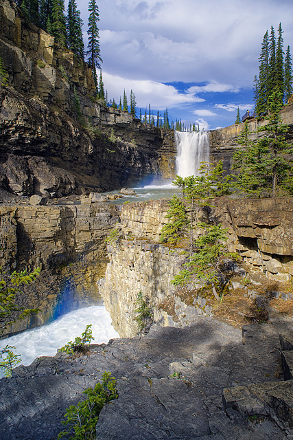
In the heart of David Thompson country, Crescent Falls is one of Alberta’s most breathtaking natural wonders.
With its stunning two-tiered cascade totalling an impressive 27 meters in height, the falls offer a mesmerizing sight that captivates visitors.
The falls are situated on the Bighorn River in the scenic Bighorn River Canyon in west-central Alberta.
The name “Crescent Falls” is derived from the unique crescent-shaped upper cliff over which the waters plummet.
While visitors can drive directly to an observation deck at the waterfall’s brink, an easy hike along the top of Bighorn Canyon provides alternative panoramic vistas of the falls.
For those wanting to get up close to the falls, multiple hard-scrabble trails lead down to the middle and bottom tiers, each offering unique perspectives to the plunging water above. These trails are not for the faint of heart, and hiking poles and sturdy boots are recommended!
Safety is paramount once on the ledges of the falls; there have been numerous tragic incidents where tourists have slipped off the edge when a surge of water or spray has made the rocks too slippery to stand on.
Originally known as the Bighorn Falls, the scenic beauty was first mentioned in 1892 by geology professor Arthur Philemon Coleman. He suggested the falls offered better scenery than many other sites he had ever seen.
Crescent Falls is accessed west of Nordegg on Highway 11 through a short, well-signed access road along the Bighorn Canyon.
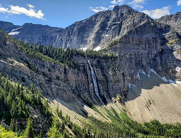
Ram Falls
Set amidst the serene wilderness, Ram Falls rivals the beauty of Crescent Falls. Its untamed environment and fewer visitors set Ram Falls apart, ensuring a more secluded experience.
This single-tier waterfall, plunging 20 meters onto the sandstone rock below, offers visitors an awe-inspiring spectacle.
While one cannot get close to the cascade, a staircase leads to a viewing platform offering a panoramic vista of the falls and the surrounding Ram River valley.
This vantage point is often accompanied by sightings of iconic Bighorn Sheep roaming along the river banks.
Just 65km south of Nordegg on Forestry Trunk Road 743, Ram Falls can be accessed from Nordegg or Rocky Mountain House.
The journey to Ram Falls promises a rustic escapade, as the road, while scenic, can be rugged and winding. Travellers should bring a map since this region’s signage and cellular reception are sparse.
Once there, Ram Falls Campground offers campers a tranquil retreat from the urban hustle and bustle despite minimal amenities.
The unserviced campground, which doesn’t have either drinking water or firewood, advises visitors to come well-prepared, especially considering the chilly nights characteristic of the early and later seasons.
Crypt Falls
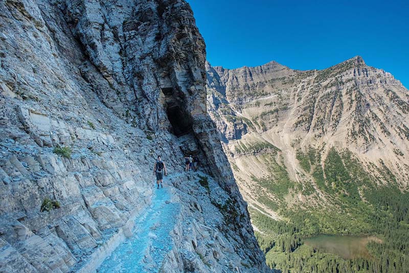
If you like to get away from crowds that come with road accessibility, then Crypt Falls might be the wilderness adventure you crave!
Crypt Falls is a centrepiece of beauty on the renowned Crypt Lake Trail in Waterton Lakes National Park.
After National Geographic named the trail among the world’s most thrilling hikes, its allure has only been magnified.
To witness the splendour of Crypt Falls, adventurers embark on the famed Crypt Lake Trail, a journey known for its end view and the adventure it offers.
After a scenic boat ride across Upper Waterton Lake, hikers are treated to the sights of four breathtaking waterfalls along a 17.4km round trip day hike, taking between 5 and 7 hours to complete.
You won’t be alone, however, as the boat can take upwards of 50 hikers at a time. But in short order, hikers spread out on the trail as they vary in speed and stop at different points of interest.
As the trail progresses, hikers must climb a steel ladder, navigate through a narrow tunnel nearly 100 feet long, and tread carefully above a steep, daunting cliff, holding onto a secure steel cable for safety.
It’s an unforgettable experience and is not recommended for beginning hikers. Also, grizzly bears are common here, so bear spray is well advised.
The trail has been voted Canada’s Best Hike since 1981 and is recommended for anyone seeking an adventurous day hike infused with epic scenery.
The ideal time for this journey is between April and September when the weather is usually bright and cheerful.
Near the trail’s end, the stunning view of Crypt Falls emerges.
Sourced from Crypt Lake above and cascading into a smaller lake below, the exact height of the Crypt Falls remains a mystery, but it’s believed to be grander than current estimates of 200 metres.
This mesmerizing waterfall is believed to have formed from an extinct volcanic crater, with a section of its northern part collapsing, giving the waterfall its current plume over a steep cliff.
Focus on the time on this hike because if you miss the last boat back to the Waterton Townsite from Crypt Landing, you’ll spend the night huddled on the shoreline without shelter! Remember you’re on a schedule; give yourself plenty of time to return from Crypt Falls.