Glaciers have carved out the the mountain landscape of Alberta that we love.
And our glaciers attract millions of visitors a year, yet these rivers of ice are disappearing before our eyes.
Take the world-famous Athabasca Glacier, for example. This iconic glacier above the Icefields Parkway (Hwy 93) is visited by hundreds of thousands of tourists annually.
It forms the headwaters of the Athabasca River.
It’s one of many rivers that flow from the Rockies, irrigating farm fields, filling the reservoirs that Albertans depend on for drinking water and powering our oil sands industry.
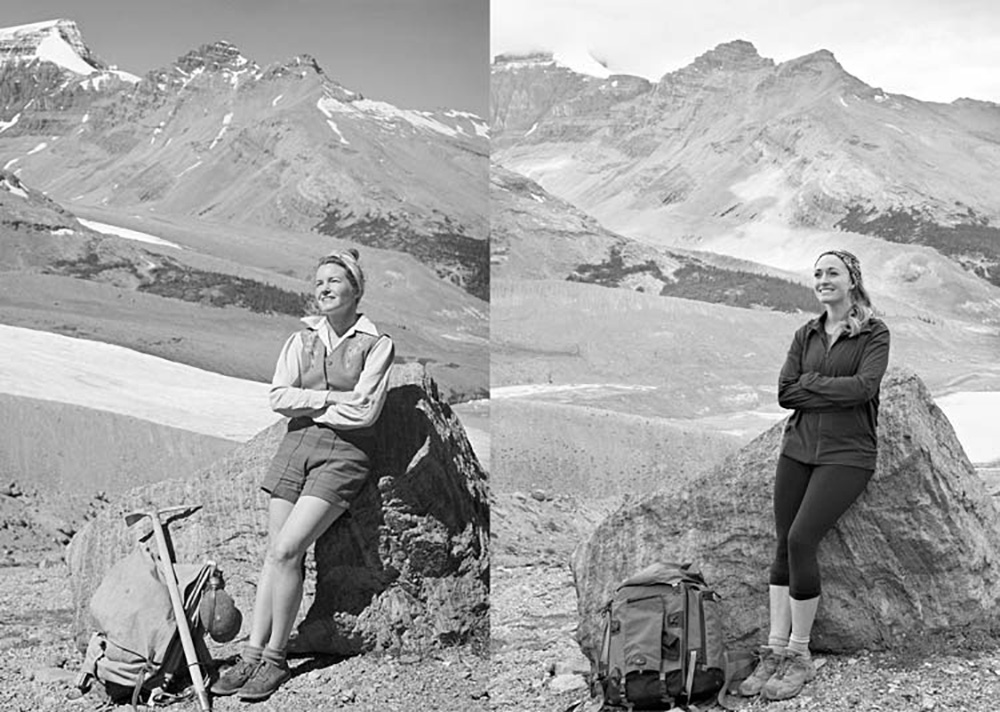
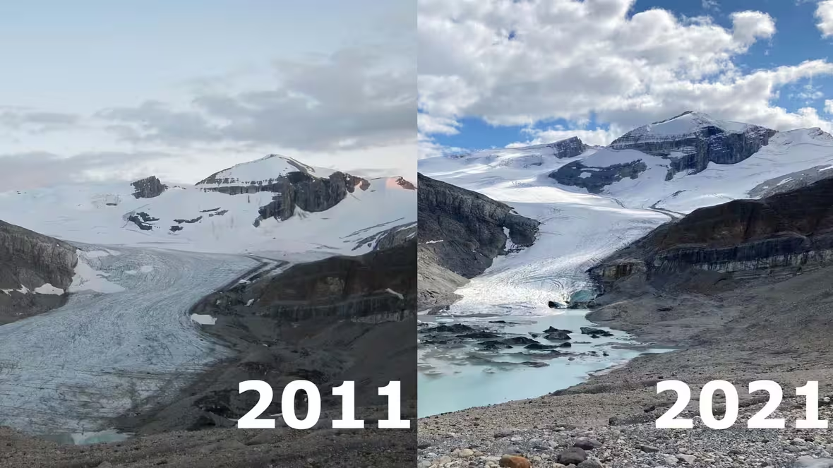
In the past 125 years, the Athabasca Glacier has retreated 1.5 km and lost half its volume, and the rate of retreat accelerates each year.
This story of rapidly melting glaciers is unfolding in mountain ranges worldwide.
This is why the United Nations declared March 21 the World Day of Glaciers, starting next year.
The United Nations initiative aims to raise awareness about our changing climate and help provide solutions to slow the shrinking of glaciers, which store water that nourishes communities worldwide.
Alberta’s Glacier Hit List
Great West Media recently compiled a list of iconic glaciers to see this summer.
We have to agree – it’s a great list.
So we’ve fleshed out that list and presented our “must-see glaciers” checklist for this summer.
Our road trip takes you along the iconic Icefields Parkway to see six of the best Canadian Rockies glaciers.
To help you plan your trip, we’ve listed the glaciers from south to north.
Hector Glacier
This glacier descends from 3,394-meter-tall Mt. Hector, towers above the east side of Icefields Parkway about 18 km north of Lake Louise.
It’s named after James Hector, a famous naturalist, geologist, surgeon, and explorer.
He was a member of the Palliser Expedition sent to explore railway routes through the Canadian Rockies.
In 1938, a massive chunk of the glacier detached, blanketing the valley below with ice as thick as 60 meters (200 feet). The colossal ice mass obliterated everything in its way, marking only the second recorded glacier hazard in the history of the Canadian Rockies
Hector Lake Trail is an easy walk along the shores of the lake on the west side of the parkway. It offers amazing views back to the glacier.
Here are the directions from Lake Louise to Hector Lake Overlook.
Crowfoot Glacier
One look at this spectacular glacier with its three-finger shape, and you’ll understand why early explorers named it “Crowfoot.”. The recent melting ice has made the crowfoot design less obvious, but it’s still beautiful.
The glacier can be easily viewed from the Crowfoot Glacier Viewpoint on the Icefields Parkway, which is about 36 km from Lake Lousie.
Be aware that this viewpoint is a major stop for tour buses and can be loaded with people and vehicles all vying for a photo of the glacier.
Alternatively, for a quieter view and a great hike you can lace up your boots and head up the Helen Lake Trail, rewarding you with aerial glacier views and beautiful alpine meadows full of wildflowers.
Here are directions from your last stop, the Hector Lake Overlook, to the Crowfoot Glacier Viewpoint.
Peyto Glacier
Named after legendary horse outfitter and guide Bill Peyto, this glacier extends from the smaller Wapta Icefield.
Because of its rapid retreat, the Peyto is one of the most studied glaciers in Canada.
It’s also one of the most photographed, thanks to the Peyto Lake upper Viewpoint along the Icefields Parkway, which overlooks Peyto Glacier’s famous turquoise-coloured namesake lake.
You can see Peyto Glacier, or what’s left, from the famous lake viewpoint. If intrepid, you can hike the Peyto Glacier Via Caldron Peak Trail to get up close and personal with the glacier.
The Peyto Lake Upper Viewpoint is only an 8 – 10 minute drive from your last stop.
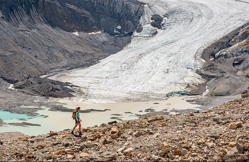
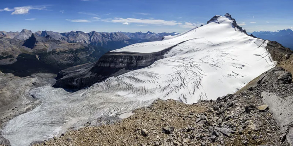
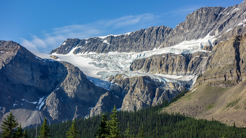
Saskatchewan Glacier
At 13 km long, this is the largest outflow glacier of the Columbia Icefield.
The lovely Parker Ridge Trail, one of the most popular day hikes along the Icefields Parkway, is a perfect way to view the stunning glacier and surrounding rugged mountains.
Snow Dome, a mountain located on the Continental Divide, is a peak in the Columbia Icefield region known as a hydrological apex.
It’s where three massive watersheds intersect, which means runoff from Snow Dome flows to three oceans—the Pacific, Atlantic, and Arctic!
The Parker Ridge Trail is located in Jasper National Park, approximately 78 km from the Peyto Lake Upper Viewpoint.

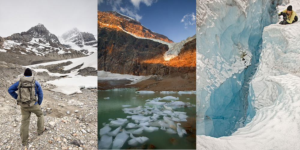
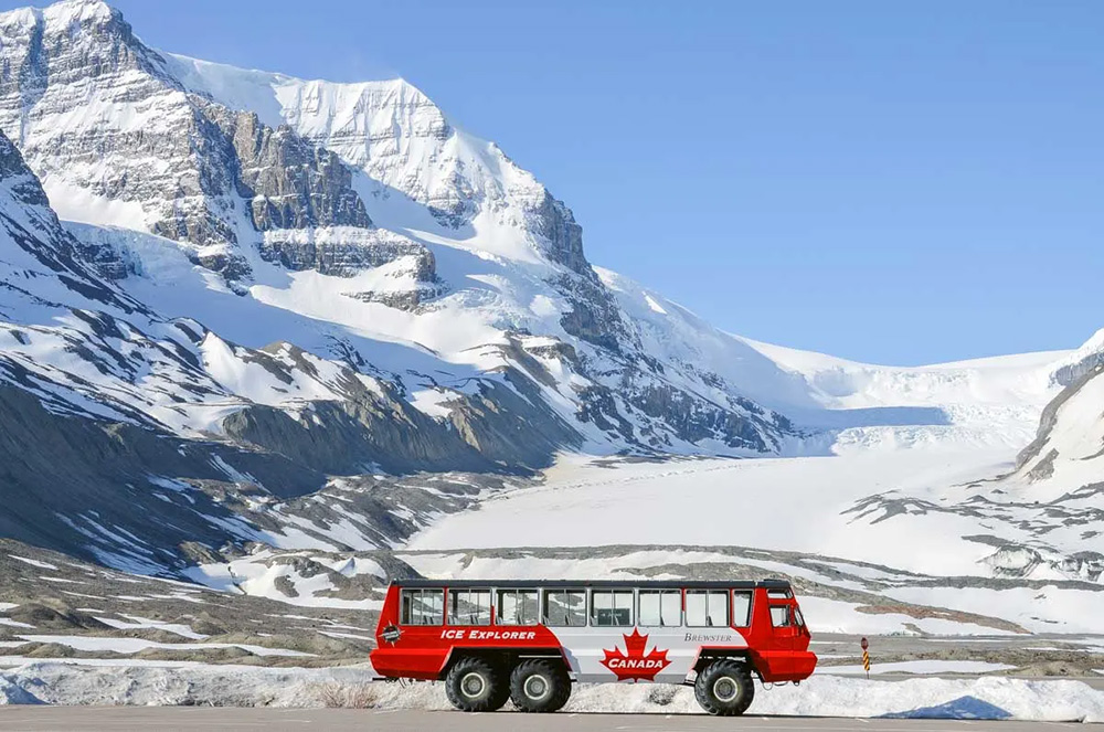
Athabasca Glacier
The Columbia Icefield feeds this glacier.
It’s the most visited glacier in North America because it is easy to access along the Icefields Parkway.
You can park your car right below the glacier and do a short self-guided interpretive hike with up-close views of the glacier.
It’s also a great place to go to school on glaciers. You can join guided hiking tours on the glacier or book a seat on an Ice Explorer, all-terrain vehicles that allow you to learn about the glacier while viewing it.
The Columbia Icefield Skywalk is nearby and offers panoramic views of the glacier and surrounding valley from a glass-floored platform perched high above the Sunwapta Valley.
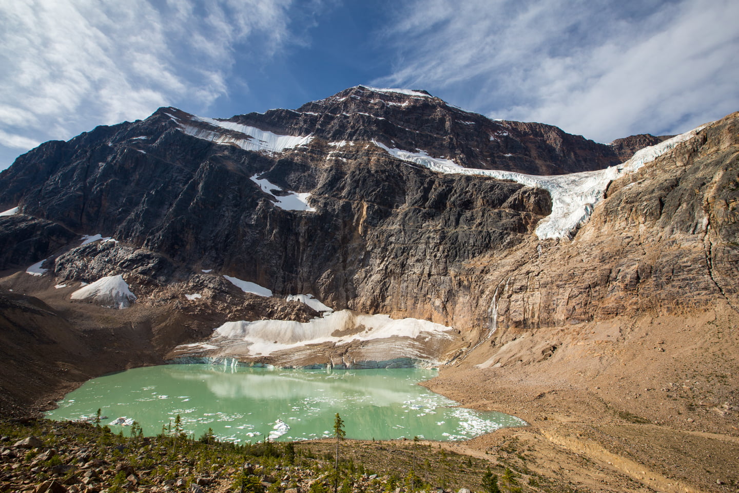
Angel Glacier
Clinging to the north face of Mt. Edith Cavell near Jasper, this stunning glacier gets its name from its angel wing shape.
It’s a hanging glacier that ends abruptly at a sheer cliff, dropping ice and snow onto Cavell Pond far below.
The short Path of the Glacier Trail is an easy out-and-back hike that offers a fantastic view of the Angel and, in summer, amazing wildflower displays.
From your last stop, it’s 123 km to the trailhead to see Angel Glacier.
There are other glaciers to visit in Alberta; in fact, Alberta has a total of 741 glaciers, 81% of which are smaller than one square kilometre. These small glaciers account for only 23% of the glaciated area in Alberta.
Most of Alberta’s glaciated area is formed by the 14 major icefields and valley glaciers, including the famous ones listed here.
But even these big glaciers, which are larger than 10 square kilometres each, are quickly shrinking year by year.
So go see them before they are gone. Or can we make the changes needed to save the glaciers for future generations?